GEOMORPHOLOGICAL SURVEY
It is clear that the form of the beach is changing as it rises and becomes steeper. In 2021, a Geomorphological survey was undertaken to inform future beach management decisions.
Source: Foster et al. (2013)
Figure 32: Indicative UK intertidal mudflat and saltmarsh profile. Look at this in the context of the beach profiles, and note in particular Mean High Water Spring (MHWS) levels, to understand how tidal reach and sand levels dictate the types of vegetation and their function. From this we can better understand why Puccinellia maritima is now the dominant species above MHWS across much of the profile area, and why it is likely to spread as beach levels increase and the MHWS line retreats.
Source: Wirral Council
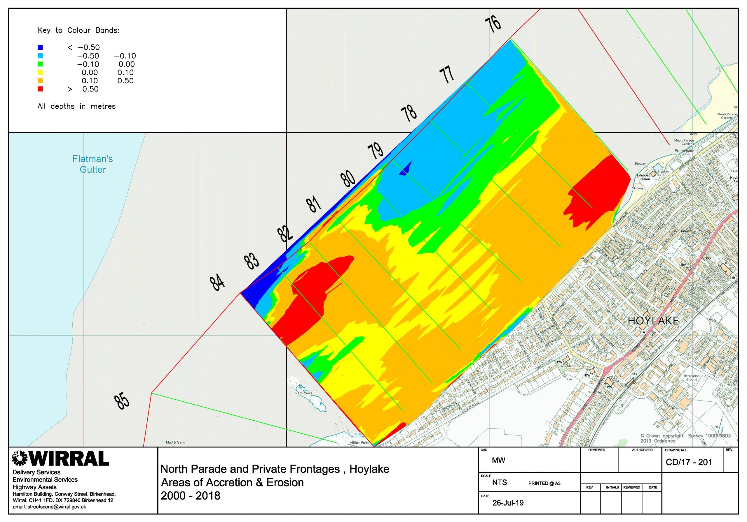
Figure 33: Chart of beach accretion and erosion trends between 2000-2018; valuable information for future coastal management planning. Note how the beach is becoming steeper especially between profiles 76 (new lifeboat station) and 80 (Courtenay Road). As it does so, tidal drainage can become more efficient and the upper beach can become drier, less silty and more sandy.
Figure 34: As well as the extent and distribution of sand-accreting vegetation, the rate of windblown sand transport, tidal action and even the size, distribution, moisture and pH of sediment particles also impact on whether, where and how dunes form. We can see ‘hummocks’ of sand emerging at Hoylake; if undisturbed then natural aeolian processes can quickly lead to embryo dune formation, followed by new vegetation types becoming established such as Sand Couch (Elytrigia juncea) and Marram (Ammophila arenaria).
Source: Wirral Council
Figure 35: A profile from the Old Lifeboat Station showing accretion between 2000 and 2018: we can see how, as a result of this, the retreat of the Mean High Water Spring tideline (MHWS) over time (between points (a) and (b) above, impacts on where different types of vegetation establish (see figure 32). As the sand levels rise, Puccinellia maritima, is more likely to establish on the upper beach between MHWS tideline and the Highest Astronomical tideline (HAT).
In its conclusions and recommendations, DEFRA’s 2007 document Sand dune processes and management for flood and coastal defence Part Four: Techniques for sand dune management states:
“Wherever possible, coastal dune and beach systems should be allowed to respond naturally to changes in forcing factors and sediment supply conditions. Where accommodation space exists and conditions are favourable, frontal dunes should be allowed to roll back to establish a new equilibrium. However, in areas of low wind energy or strongly negative beach sediment budget, dune dissipation is likely to occur unless nourishment with fine-grained sand and artificial dune profiling are undertaken. It is recommended that a detailed Geomorphological Evaluation Study should be undertaken at each dune site, or group of sites, to assess the requirements and to identify the most appropriate management strategy. This will require nature conservation and other interests to be taken into account. Where not in existence, systematic monitoring programmes should be set up to provide early warning of dune change. Data should be obtained in a standardised format which can be exported for centralised analysis.”
A local geomorphological survey is urgently needed to gather up-to-date information including past, current and projected sand accretion and erosion, sediment analysis and mapping wave energy, vegetation, tidal and wind impacts. The cost of a geomorphological survey would be considerably less than is spent each year on reactive beach management and the removal of windblown sand.
Just how these unique factors interact with each other at a particular site determines how a dune system might emerge and develop over the long term. Such a survey would, therefore, give a better indication of the potential form and size of a dune system while providing a valuable evidence baseline for future beach management decisions.
What is clear is that on the North Wirral Foreshore at Hoylake in 2019 there was a huge increase in the amount of sand accreting saltmarsh species, notably Puccinellia maritima, which, when combined with the clearly evidenced and abundant supply of dry, windblown sand, strongly suggests that a dune system is likely to form, and Birkdale offers a good example of how a system at Hoylake might emerge.
But the more data we have the better: sediment size; the distribution, depth and even pH of silt and sand deposits; energy and reach of mean Neap, High, Spring, and Highest Astronomical Tides; accretion, erosion and beach profile; vegetation types and distribution; wind speed and direction; and projected sea-level rise… all of these have a unique role to play but are also interdependent.
In this context, it is perhaps unsurprising that the simple, reactive beach management approaches of the past, based on a severely limited and out of date evidence base, have consistently failed.


